Friday, May 31, 2013

Colorado!

Sara ready for lunch in Colorado
Yesterday afternoon we crossed the border into Colorado and dropped down to Cumbres Pass for our next resupply.  To get there though we had an interesting day on and mostly off the trail.  The last few days we have climbed up into some mountains and camped around 10,500 feet for a couple nights.  In this part of the world that means there is still snow on shady slopes.  To get to Cumbres Pass the trail was supposed to wind along a snowy ridge before meeting with the road.  Since we had taken one of the alternate routes and were coming at the trail from a side canyon we missed the trail under all the snow and spent some time with pointless downs (steep) and ups (steep).  I learned how to do some sideways barrel-roll out of a glissade, land on my backpack and roll upright though so that's a plus.  Eventually we got back on the right track and found the pass, which came after this incredibly windy ridge that required us to use our hiking poles to keep from blowing over.  I don't think we will ever be accused of not taking the scenic route.

Both my mom and Sara's parents met us in Chama (back in New Mexico from Cumbres Pass) with our next box and some warm/snow gear.  We start again this morning and head into the southern San Juans to see how we handle some real snow on the way to Silverton.


Left jelly beans for the next hiker (Whoopin' Stick) at the border


Sunday, May 26, 2013

Trail Names and Cold Beverages


San Pedro Parks

This stretch was a relatively short resupply at only 2.5 days.  We are now at Ghost Ranch, one of Georgia O'Keefe's haunts, and taking a zero day.  Hopefully this gives our feet some time to get rid of some aches and pains as we head into our first round of real snow in the next few days.  We also just found out that Cowboys and Aliens, as well as a bunch of other famous movies, were filmed or partially filmed here.  I am now on the lookout for Harrison Ford, Daniel Craig, and of course Olivia Wilde. 


After leaving the library in Cuba we ran into a group of guys at the Saveway we have been hiking with and around for the last week or so.  A big part of thru hiking is trail names, which you are not allowed to give yourself, so we had been hoping that these guys would come up with names for us.  They did not disappoint.  Typically the names reflect either some expression you repeat repeatedly, some quirky mannerism, or something you really enjoy.  Names we have run across so far on the trail include: Don't Panic, Mountain Rat, Turbo, Mr. Furious (not furious at all), Whuppin' Stick, Naughty Eyes, Half Ounce, Green Flash, Bird Man, Bloodbath and Rampage (boyfriend and girlfriend), Nicotine, and the Czech Express.  Trail names supposedly began as an Appalachian Trail thing a while back as a fun way to remember people.  As Don't Panic put it, "I will meet a lot of Ryan's and Scott's but probably only one Naughty Eyes."  So, thanks to Turbo, Sara and I are now called Track and Field.  I am Track because I run/coach track, and Sara, Field, because she pole vaulted.  We also like to think it is because I stay on the trail/track and Sara follows every cow path into the field.  For the next few months we are no longer Forrest and Sara, but officially Track and Field.


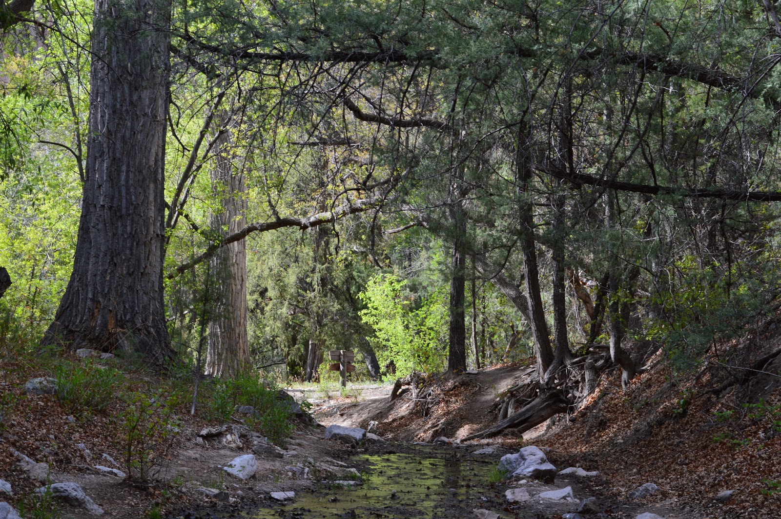
Leaving Cuba we quickly gained elevation into the San Pedro Parks Wilderness.  Here we had our first taste of snow covered trail, although it was only feet at a time, and beautiful mountain streams and forests.  The Parks were the headwaters for various streams and rivers and were vast rolling meadows full of shallow, snow-melt water.  We both quickly soaked our shoes, but I did not mind so much because it was gorgeous, and Field did not mind because she had a massive headache.  It was great not having to carry too much water, but that only lasted for a few hours.  Just as quickly we dropped

Moon rise

back down out of that wilderness, across a valley and up into a drier wilderness.  Fortunately we found Fuentes Spring to be flowing and very clean.  We filled here and then went straight up the side of a ridge to try and find the trail again before the storm clouds opened.  Before we made the trail we came across an old road bed that created a bench way up on this steep slope overlooking the Fuentes Rivershed.  We opted to camp here and watch moon rise a day shy of full.  It was absolutely gorgeous. 


Rio Chama
The next morning we found the trail and dropped over into the next canyon, Los Ojitos. We then followed this down to the Rio Chama.  This river looked to be flowing between 500 and 800cfs, so quite a bit of water for the desert (we dropped back down to cactus and other prickly bushes), and seemed very refreshing.  The river was surrounded by sheer walls of some sort of sandstone and heat mirages.  Since we had decided not to carry a raft with us we had to walk the 7.5 miles of boiling gravel road instead of float down the river.  After a lunch of attempting to soak feet in the frigid water, the road turned away from the river and into a broad valley of sun.  After about an hour and one turned down offer for a ride, a couple guys heading towards the river offered us cold drinks.  At this point we were quite parched and our river-soaked shirts had moved past the drying stage, the sweat soaked stage, and were back to dry stage, so anything cold sounded good.  He asked what we wanted and pulled out a couple very cold Tecate's before continuing on his way to the river.  That made the rest of the road walk go by very quickly and totally made our day. 

We turned off the road to follow a fence line then nature trail into Ghost Ranch.  During part of the cross country section we came across some interesting rock formations that were laid out in almost irrigation type patterns.  It looked like huge circles or squares.  They also crossed current property boundaries so were older than barb wire.  I was not sure if they were used to retain moisture or soil, or by whom.  If you have any ideas please comment.  All the rocks were small but laid in rows about 3-6" off the ground as seen in the picture. 

Rocks continued in huge circles or squares, multiple rows, gradual slope


So far Ghost Ranch has been great.  We have showers and laundry and an ice machine, plus hiker boxes with plenty of granola bars and marshmallows.  It is weird not hiking but also nice to stay off our feet.  Our next resupply is at Cumbres Pass, then into Colorado! 

Happy Trails

Track and Field

Thursday, May 23, 2013

Mt. Taylor (not racing) and beyond.

Cuba, NM-just over 500 miles and 273 switchbacks

The last post I wrote in a quick frenzy since my dad was hungry and wanting to take us to lunch, so I did not get to edit it or mention that the Flag High track team ran AWESOME at the state championships.  The girls 4x800 repeated as state champions and Tatiana won the 3200 and the 1600.  The boys 4x800, placed 5th after being seeded 15th, but I have yet to see that video because Calvin (calling you out) has not sent me a link yet.  Congratulations!

In trail news, we ended up leaving Zeno with my dad.  He had difficulty getting out of the car in Grants so we would not have been able to do nearly enough miles, or carry enough food, to make it work.  It was, yet again, a tough and sad decision but he is home for good now. 

We left Grants Sunday afternoon right after a rainstorm came through and hiked out in clouds.  The first few miles followed the bike route of the Quad, until we passed the prison, before taking a trail (a real live trail) up the mesa towards Mt Taylor.  We thought it would be a good idea to camp at the edge of a meadow where we could see the mountain but that ended up being the windiest and coldest spot during the night's rainstorm.  We awoke cold and began the last few miles up to the summit where we were in time to see the last of the fresh snow melting.  The view from up top was incredible.  During the Quad I was in such a dazed fog at the top and Sara was looking at the view in the wrong direction that neither of us noticed the great bowl on the inside of the mountain.  This area definitely needs more exploring. 

The trail took us down the backside of the mountain where we rejoined the official CDT and trudged north.  The next day (31 miles) we dropped into an awesome valley created by the Rio Puerco, which had numerous mesas and arroyos and very little water.  We spent the entire next day (28 miles) trying to get from one water supply to another in very hot weather.  The views were incredible and we were on nearly all trail, but the heat and aridity made it tough going.  We finally made it to a spring as the sun set and camped under a nearly full moon. 

A tradition we started at the beginning of our hike that seemed like a fun idea and is now turning into a ridiculous and painful idea is pushups.  We decided to do a pushup for every day on the trail.  Day 1 we did one.  Day 5 we did five, etc.  Today we need 26.  I thought that if we built gradually I would get strong enough to handle this, which I might be, but the pain level increases with each day.  I am hoping to make 30 before I have to break it into sets.  I am also thinking we should switch to snickers for every day on the trail. 

Cuba marks the end of desert for the most part.  This afternoon we start into some mountains with a creek and river and climbing and fun!  We're getting reports of lots of snow in CO so our hike is about to be very different. 

I am trying to post a lot of pictures but Sara's super fancy camera has too big file sizes for most library internet speeds (like this one).  More are on my facebook page. 

Happy Trails!

Sunday, May 19, 2013

Rivers, Roads, and Volcano Poop

Grants, NM  396.5 miles, 130 switchbacks

This last stretch we have had a bit of everything.  Cold rain and snow hit us in the Gila River area, lots of sunny, warm stretches of road pounded our feet to death, and gnarly lava rock that looked like volcano poop kept things interesting.
Sopillo Creek as it flows into the Gila


From Silver City we took a road northwest into the depths of the Gila National Forest.  The first morning we followed bear tracks in the beautiful Little Bear Canyon, which was just a preview of the Gila River.  From Little Bear we climbed up and around the Devil's Garden with incredible granite formations and apparently a hermit (who we missed) who had been there 14 years.  In late afternoon we dropped into the Gila River.

The next few days were my absolute favorite section of New Mexico.  There were no bridges so we had to cross the river by wading, but the water was warm.  There were high sweeping walls and the river meandered back and forth.  There were a few areas of hot springs, which when we go back we would like spend more time near.

First mile on the Gila River
After a few days of the lower Gila we got to Doc Campbell's where we had a box waiting.  We packed for 9 days of food to get us to Pie Town, only to find out that it takes 7.  We opted to cut our 20+ mile days down a bit so we could eat some food weight.  The Upper Gila seemed a completely different canyon.  The walls narrowed and got higher so it seemed like the bottom of the Grand Canyon.  The last day in the canyon huge thunderheads rolled in.  The clouds were so big that they created their own cirrus clouds on top.  That is a storm.

After a few cold nights, open plains, a fire lookout tower, and brutal roadwalk we made it to Pie Town and Nita's Toaster house.  Nita still lives in town, but in a different house and has left this one open to hikers and bikers.  There was food, clothing and little mementos tucked in every nook and cranny.  We stayed with 7 other hikers that night, and it was fun to swap stories and see some other crazies doing this.

Crossing number 4 of 194
Sara and I left early the next morning on the worst road walk yet.  We made 29 miles of nearly straight ranch road.  Fortunately we saw some mountain lions to break up the monotony.  The lions kicked up a rabbit and accelerated faster than any creature in this, or any other world has a right to be.  After that our only entertainment was a curious donkey at a water spigot and Sara trying to herd cows.

The next night we camped at the edge of El Malpais lava field, which fortunately meant we would be crossing this black surface in the morning.  The first 4-5 miles of it were incredible.  There were huge walls of lava, with ripples and old river beds to break it up.  The last few miles were much tougher walking as it became less of slab walking and more big chunks of cinders.  At the end of that section there was a table under shade though so we were able to get our feet up and let some blood drain out of them.

Flowers that only come out at night
The rest of the way to Grants (20-30 miles) was on roads.  Crossing over I-40 was a fun experience because that is the road to Flagstaff.  Although not technically north of home, it feels like now we are getting to that point.  Grants is also one of the few places that we have been before.  The last time we were here though Mt Taylor was covered in snow and we were about to race up it.  Now we can take our time and there is no snow.  The idea of going up a mountain this weekend is pretty exciting.

My dad just brought over Zeno and some extra gear we need.  Zeno is still looking pretty stiff so we are going to see how the first few miles go out of town, but if he is still limping we will unfortunately need to send him back home.  We will find that out this afternoon.

Now it is time to hit lunch and get back on the trail.  

Monday, May 6, 2013

First Peak, Road Walks, and Silver City


Currently in Silver City, 141 miles and 19 switchbacks.

Night number 5-at the end of the Never Ending Desert
The first day out of Lordsburg involved hiking toward the first hills of the Gila National Forest across another plain that never ended.  This time though it the temperatures were more manageable due to the remaining 30mph winds from the previous days dust storm.  By lunch we had officially made it out of the flat, boring desert into the hilly, interesting desert.  We stopped at a windmill for lunch where we propped up our feet in the shade (yes we actually get shade now) and looked up at the junipers, scrub oak, granite formations, and cows slurping in the trough next to us.

We found our camp three more miles down the road for a total of 18 miles on the day.  This camp was under a windmill that actually had a spigot.  No pumping water for us that night.  It was like the desert gave us a present for making it out of Lordsburg.

Spigot at the co-op windmill-night 7
The next day we hiked past some more abandoned mines on the way to the top of Burro Mtn. (8022').  Along the way we got views of far off hills and crazy granite mounds.  This area was a lot like Granite Mountain near Prescott, AZ: boulders everywhere, juniper and scrub oak, and lots of pokey things.  After lunch we summitted Burro Mountain where we could almost see to Lordsburg, but fortunately could not.  We have officially hiked farther than we can see!

That night we camped next to our first natural water source, Mud Spring, next to which we saw three turkeys and a nervous looking deer coming down for a drink.  Throughout the night we heard strange birds and various turkey calls.

Yesterday morning we booked it down Deadman's Canyon, a twisty, gnarly little drainage that had some water in it, before hitting Tyrone Road.  At this point we had 16 miles of road ahead of us to Silver City.  That last 12.6 were miserable and on Highway 90, which never seemed to end.  We did see some markings from the Tour de Gila bike race that took place this weekend, but after those ended we were left with very little entertainment.

We camped at the Silver City RV park and took yesterday afternoon and this morning pretty laid back with the hopes of recovering a little from the road walk.  Gavin started his hike on the PCT yesterday and both of us got rain throughout the night.  Sara and I certainly did not expect precipitation this early in the trip, but it smells nice and is keeping today nice and cool.

One of many blooming cactus on the trail
On a sad side note, our guide book said there is a Silver City Brewing Co. but the phone book and the address do not.

On a happy side note, Zeno has improved and is now bouncing off the walls at Addie's house.

Our next few weeks will take us through the rest of the Gila National Forest and the Gila River to Pie Town and then up through Grants where we hope to post next.

Good luck to all FHS track athletes at the state meet this week!

Happy trails!

Thursday, May 2, 2013

We love the desert....ish

Greetings from Lordsburg! 

Just about to head North!
What an interesting last few days.  We got started from Crazy Cook on schedule and made it to our water cache that night where our parents had left us brownies.  It was a hot day through the Big Hatchet Mountains with two trees.  And one of those might have been a bush.  Sara and I did fine except for a little bit of sweat getting in my eye, but Zeno started having some issues.  He went through some water and was able to cool off some but he did develop a limp towards the end of the day that concerned us.  Aside from that the scenery was bleak, dry and mostly brown.  In far off valleys we could see multiple dust devils that wound hundreds of feet into the sky.  Fortunately both of us remain in Kansas, or New Mexico.  That night we settled down to read a bit and I heard something in the bushes that kept getting closer and then got really, really close.  From the light of my kindle I could see the tail of a small snake disappear under my sleeping pad.  I moved very quickly after that and was able to get out of its way before it bit my jugular, or curl up and fall asleep.  We managed to get a picture that will be posted when we can upload our photos. 

The next day was a rough one for Zeno.  We needed 12 miles to get to the next water and it was all cross country at the base of the Big Hatchets.  He began with a severe limp that occasionally looked better then would get worse after each stop.  We managed to get to the water where we took a two hour break in our 5' by 5' square of shade, but after he could barely stand up.  We were forced to make the tough decision to hitch a ride to Hatchita/Lordsburg and send him home.  He simply would have slowed us down too much to make our next water.  Sara did a great job flagging down trucks and got the first two with one wave.  A rancher took us to Hachita then to Lordsburg when he got off work.  We spent our last night with Zeno at the KOA before our parents dropped us back on the trail in the morning. 

Day three we hiked the length of the Little Hatchets and ended up 21 miles down the trail at our next water stop.  Along the way we tested our water pump in some lovely cow water (we have not died or pooped our pants yet) then found shade in a sweet ghost mining town.  I am fairly sure that my father would get in serious trouble in this town with the open mine shafts.  Towards the end of this day I started to develop some blisters that mole skin was not helping.  By that night the middle of my feet were not in great shape.  I attempted to pop them with my pocket knife scissors, which is not the most comfortable thing. 

The next morning my feet still hurt but Sara set her crusher pace and we took off through the Coyote Hills.  So far this is our favorite area.  We saw a herd of deer and antelope cruise across the trail before we wound out of the hills down towards our fourth water cache.  At this point I was dragging a little so we took a longer break before heading across the never-ending valley of doom (Lordsburg Valley).  Imagine a wide, desolate, sun-baked, horrendous valley, then walk 11 miles across it towards a mountain that never seems to get closer.  That's about what it was.  We made it all but a half mile across for both of our highest mileage days ever, 23, and Sara's first round of blisters. 

Starting walking this morning was fairly comical since we both needed to wake up our feet.  Once we got going we entered the Pyramid Mountains amidst the beginnings of a sandstorm that blocked much of the sun.  We managed the 15 miles through the mountains to Lordsburg where we are now holed up in a motel avoiding the sand and wind. 

So far we are both doing well, aside from the blisters, and look forward to getting back on the trail tomorrow.  Tomorrow we should be camping in an area that has at least 8 trees, 3 more than we have seen so far! We will resupply next in Silver City where hopefully we can upload some pictures.

We are hoping to have Zeno rejoin us in Grants.  Thanks Addie for getting him back in shape for us!